by: jamie January 30th, 2012 comments:
In 2010, Map Kibera was awarded a Youth Fund grant from Unhabitat. With the many developments in the Map Kibera project, the

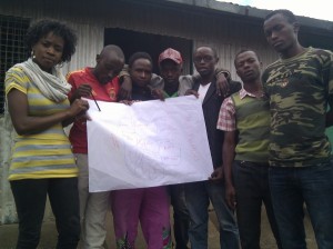
Mildred and Mukuru residents with hand-drawn village boundraies (photo credit: Primoz Kovacic)
Youth Fund grant was delayed until mid-2011. Some of the other initiatives the team was working on included the establishment of the local agency Map Kibera Trust, with support from the Africa Technology and Transparency Initiative and the expansion to work (led by Map Kibera Trust ) to Mathare and Kwale.
Map Kibera Trust received the Unhabitat youth fund grant in order to expand its work to other parts of Nairobi. Given the existing ties with Mukuru (an informal settlement in Nairobi’s industrial area) and the demand for training from young people who had been introduced to mapping in 2009 and 2010, the mappers decided to implement the youth fund grant in Mukuru.
The Unhabitat youth fund grant is designed to support organizations led by young people in developing countries. The grant involves a component of skills development; young people from selected organizations are trained in project management, documentation and budgeting. The young people then put their newly acquired skills into action throughout the project lifecycle.
Primoz and I have been supporting the mappers in Kibera, however we believe the best way to learn is through experience. And so in order to see them develop the new skills, we have taken a step back and supported the project mainly through some limited technical assistance. The field work and documentation has been led by Mildred Anekeya, the mapper coordinator (herself a young mapper from Kibera) and Vincent Mutuku and Moses Wahor, young mappers from Mukuru.
Below is a question and answer from Mildred, Vincent and Moses that documents their experiences in mapping Mukuru during the first half of the youth fund grant cycle. Â Their insights are important to those undertaking similar projects in similar contexts. These answers were submitted to Unhabaitat as part of a mid-term report.
What is the progress you have made [in mapping Mukuru]?
First of all we held two successful community forums, in Mukuru kwa Reuben and Mukuru Kayaba, which sensitized the community on the importance of mapping before we launched it. Finally we will hold other forums to confirm the mapping that we have done to the community.
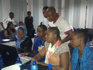
We were been able to cover all five villages of Mukuru which are Mukuru kwa Njenga, Mukuru kwa Rueben, Mukuru Lungalunga, Sinai and Mukuru kayaba. We were able to train 24 trainees in data collection which involved usage of GPS gadgets, downloading the data, editing and uploading it which involved gaining of computer knowledge. We had problems like getting approval from the local authorities but we had to convince on what to implement on the ground and later they had to approve us. We also faced minor problems from the participants which are commitment towards the training and some were demanding allowance for their time, but after giving them the importance of the training they had to commit themselves fully. Insecurity was also one the problems but we had to find ways to curb it, and this was to work the residents from the same village.
What problems have you encountered during the first phase of the project?
At first we encountered problems from the administration, allowances of the trainees they were not ready to work without being paid, insecurity especially in Mukuru Kayaba and lack of commitment from the trainees especially Mukuru Kayaba where initially we had about 12 trainees and they all left remaining with 4. The obstacles that we faced in technical issues were: too few computers which led to extension of the timeframe and also it took time for the participants to catch up with what we were teaching them. Less internet modems which lead to limited internet access.
How did you overcome these problems?
Coordinators from Mukuru had to talk to the administration concerning the project and convince them for approval. They also coordinated and made the availability of the trainee to training centre. They ensured security was intact and organized for the venues. This made the mapping process run smoothly despite the challenges. Concerning technical issues we had to make use of what we had at hand and the administration of the Map Kibera Trust made sure that we full credits for the modems and the computers were available each time we needed them.
What project activities are planned for the next 6 months?
Drawing of boundaries of the villages and their zones, drawing of paths and tracks, drawing the industries and also showing how they are close to residential areas which can be used to explain some of the risks that people in slums are prawn to, like in the case of Sinai tragedy.
Finalizing on the mapping process and ensuring that the trainees are able to comprehend what we taught them.
Making follow up on all the stakeholders that would be interested in using the final maps in their work groups such as Administration, Youth, women groups, trainees, Community based and Faith based organizations.
To understand the spread of development in every particular village and also make conclusion on how the developments could be enhanced.
Any other comments?
The mapping exercise is a very unique method of bringing out problems in informal settlements; hence it should be enhanced to cover all the slums in Kenya. The trainees will need to have ongoing exercises less they forget what they learned, this can be improved by having substations in Mukuru.
by: jamie January 28th, 2012 comments:
Throughout October and November 2011, Plan Kwale worked through Map Kibera Trust with Primoz Kovacic and I, along with 4 young people from Kibera (Zack Wambua and Maureen Omino) and Mathare (Jeff Mohammed and Javin Ochieng), to conduct digital mapping exercises to support ongoing youth-led development processes in Kwale county. One of the important lessons learned through the Trust’s work in Kibera and Mathare is that the stories behind the mapping work are important for understanding the processes that contribute to a situation as represented on a map. To tell these stories and to complement the data collection and mapping work done by the youth in Kwale, the Map Kibera Trust team worked with the Kwale youth to set up platforms to share this information nationally and internationally. Sharing the important work being done in Kwale will hopefully bring greater visibility to the issues which may in the longer term lead to greater impact.
Sharing stories of local governance
To support their work on social accountability, the Kwale Youth and Governance Consortium mapped over 100 publicly and privately funded community-based projects. The projects were supported by the Constituency Development Fund (CDF), Local Area Development Fund (LATF), NGOs and private donors. As one channel of sharing this information, the Consortium set up a blog called Nuru ya Kwale (Light of Kwale). According to KYGC the blog “features and addresses issues concerning promotion of demystified participatory community involvement in the governance processes towards sustainable development. We therefore expect interactivity on issues accruing around social accountability.†This involves sharing evidence about various projects and stories from the community.
One example is the documentation of the Jorori Water project in Kwale; through the mapping work, the Governance team collected details of the constituency development fund (CDF) project. The funding allocated to upgrade the water supply for the community was 6,182,960 ksh (approximately 73,000.00 USD). From their research the KYGC identified that the Kenya Open Data site reported that the full funding amount has been spent. A field visit to the site however revealed that project was incomplete and the community is still without a stable water supply, despite the fact that the funding has been “spent.â€

Read more about the questions the team raised in terms of the governance of CDF projects, including the detailed the project implementation process and some reflections on why the project stalled. This is information on community experiences (tacit information) that is well-known in a localized context but has not been documented and shared widely. New media tools, a blog in this case, provide free (if you have access to a computer and the internet) platforms for sharing this information with national and international audiences.
Addressing violence against children and child protection
Another blog was set up by the Kwale Young Journalists. The Young Journalists, registered in 2009, have been working with Plan Kwale on various projects, including Violence against Children campaigns. The group has been working to set up a community radio station in Kwale to report on children’s issues. Thus far, their application for a community radio frequency has encountered several challenges – new media provides an interim solution and will allow the team to share their stories and network with partners on a national and internal stage.
The Kwale Young Journalists worked with Jeff Mohammed, a young award-winning filmmaker from Mathare Valley. The YETAM project not only equips young people with skills, but through peer-learn establishes connections between young people working on community issues throughout Kenya. The programme also provides young people with life skills through experiential learning – Jeff reflects on his experience in Kwale and says:
“My knowledge didn’t come from books and lecturers it came from interest, determination and persistence to know about filmmaking and this is what I was seeing in these Kwale youths. They numbered 12 and they were me. They are all in their twenties and all looking very energetic, they had the same spirit as mine and it was like looking at a mirror. I had to do the best I could to make sure that they grasp whatever I taught.â€

Jeff worked with the Young Journalists on a short film called “the Enemy Within.†The film, shot with flip-cameras, tells the story of 12-year-old girl who is sold into indentured labour by her parents to earn money for her family. During the time she spends working, the young girl “falls prey of her employer (Mr.Mtie) who impregnates her when she is only 12 years old.†Jeff reflects that “early pregnancies are a norm in the rural Kwale area and what the young filmmakers wanted to do is to raise awareness to the people that its morally unacceptable to impregnate a very young girl, in Enemy Within the case didn’t go as far because the village chairman was bribed into silence and didn’t report the matter to higher authorities.†This is a common scenario in Kwale, and the young journalists plan to use the film in public screenings and debates as part of their advocacy work in the coming months.
Jeff and the Kwale Young Journalists shot the film in four days – they travelled to Penzamwenye, Kikoneni and also to Shimba Hills national park to shoot 7 scenes for the movie. Read more about Jeff’s reflections on working with the Kwale Young Journalists on his blog.
Sharing ecotourism resources
The Dzilaz ecotourism team – a group that encourages eco-cultural tourism in Samburu region of Kwale count – also integrated social media into their work. During the last week (November 8th-12th) the group set up a blog to market the community resources, services and products. They also plan to document eco-culture sites and the impact that eco-tourism can have on the community. As of November 10th, 2011 the Dzilaz team had already directed potential clients to their website and thus secured a booking through the information they had posted.
The importance of telling the stories behind the maps
One important component to mapping work is to tell the stories behind the map. The three groups in Kwale are working to build platforms to amplify their grassroots level work in order to share stories and lessons learned; the information documented on the various platforms will hopefully develop over time and contribute to a greater understanding of the processes at a local level – and where youth as young leaders can intervene to begin to change the dynamics of community development.
—
Cross posted on Linda Raftree’s blog Wait…What? and my health geography blog.
by: jamie January 13th, 2012 comments:
The Map Kibera team had a busy end to 2011. From August to the end of December 2011, we have been involved in projects in Kibera, Mukuru (Nairobi), Kwale (Coast) and Dar es Salaam (Tanzania). Mappers from Kibera have travelling across the city, country and even regionally to share their skills with other young people in East Africa. They trained approximately 40 young people in Mukuru, 30 in Kwale and students from Ardhi University in Dar es Salaam. This networking and sharing is beginning to create an informal network of young people, with skills, experience and passion for mapping for change. Although they are not always working in Kibera, the exposure the mappers get also helps to continue to “put Kibera on the map.”

Work on the atlases and wall painting for Kibera is also ongoing. The final edits are underway and 2012 will be busy for the team – producing an atlas distribution strategy, contacting partners for atlas request, visiting schools and health clinics and painting walls! Of course, the team will also gather feedback and document the process to being to better understand how community information can lead to change.
As we move into 2012, the Map Kibera team wishes you a wonderful start to the new year!


