We’re now on our second week out mapping Kibera. Our group of intrepid explorers has had two days of training, two days out mapping their neighborhood, and now two days in the computer lab uploading and editing their map data. They have been quite patient and dedicated to the task of learning new computer software, and we’ve pretty much brought the Sodnet offices to maximum computing capacity. Thankfully, we have five technical volunteers who are helping them learn the OpenStreetMap program, upload data, and scan in their paper maps.
We’ve now changed our schedule to accommodate the extra time – and focus — needed in the computer lab – spending one full day in the lab, then one full day in Kibera mapping and discussing our progress.
Here in the lab, we’ve found that computers are funny partners for those who weren’t brought up on Windows, much less Facebook (though we’re proudly starting a Facebook group!). There is the whole problem of click-and-drag, of click versus double-click, of opening and finding something in a web browser as opposed to a folder or flash drive, of typing web addresses precisely and passwords with proper capitalization (common practice is to flick on caps lock instead of shift). The use of a computer is not actually as intuitive as I had come to think. Certainly the keyboard, with its shift and control keys and illogical location of the letters, is not a straightforward tool. A few times, I have been reminded of how I painstakingly studied typing in grade school via a little computer program called Mavis Beacon Teaches Typing. Thanks Mavis! Wish I had a copy for our participants now.
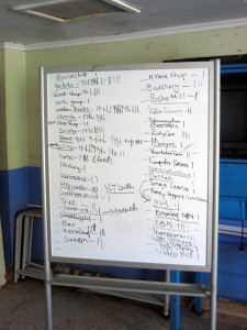
But the fact is, after just three days in the lab and two days in the field, we have quite an impressive amount of marks on the Kibera map. It’s starting to not only resemble other urban areas with churches, schools, and public toilets marked in abundance, but also to reveal the astounding density of the place. After the second day out mapping, we took just five of the villages and had the mappers tally the features they recorded. Here’s the impressive list they made:
I spent Friday morning walking around the village of Raila with Regynnah, one of the mappers, tripping up the dirt pathways alongside trenches filled with running waste water, past small kiosks selling soda and cell phone top-up cards and toddlers chanting in unison “how-are-you!” We stopped at a few pre-primary schools – they seem abundant – and were treated to a little dance and song at one of them.
We toured a toilet facility under construction, and marked an AIDS clinic, chapatti shop, a cobbler. The sheer amount of potential landmarks led me to wonder what everyone had decided was important to map, and we came to a kind of consensus after making that list on the whiteboard. Then underlined features are essential to map, the rest are up to individual discretion.
So the next challenge on our plate is to help build bridges to make use of the information and demonstrate where it fits in to the bigger picture. We’re bringing in various speakers to Kibera to share some of the possibilities for this kind of mapping and introduce the participants to the wider world of technology. So I would say our ambitions are high – it’s a matter of not only teaching computer skills but envisioning the mappers as eventual full participants in the global wired world.
so completely awesome!!